
پەڕگە:Strait of Gibraltar perspective.jpg

قەبارەی ئەم پێشبینینە: ٨٠٠ لە ٤٨٠ پیکسەڵ. ڕێزەلووشنەکانی تر: ٣٢٠ لە ١٩٢ پیکسەڵ | ١٬٠٢٤ لە ٦١٥ پیکسەڵ | ١٬٥٢٨ لە ٩١٧ پیکسەڵ.
پەڕگەی سەرەکی (١٬٥٢٨ × ٩١٧ پیکسڵ، قەبارەی پەڕگە: ١٨٢ کیلۆبایت، جۆری ئێم ئای ئێم ئی: image/jpeg)
کورتە
| وەسف |
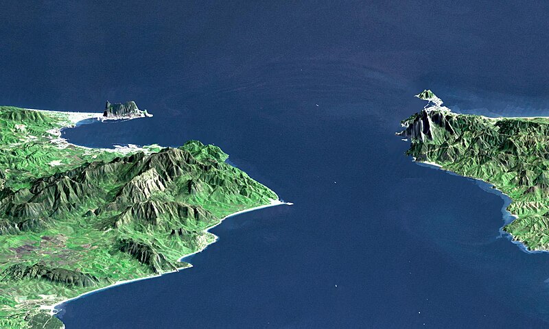
English: "This perspective view shows the Strait of Gibraltar, which is the entrance to the Mediterranean Sea from the Atlantic Ocean, with a 3-times vertical exaggeration to enhance topographic expression. Europe (Spain) is on the left. Africa (Morocco) is on the right. The Rock of Gibraltar, administered by Great Britain, is the peninsula in the back left." (quotation taken from the more detailed NASA description page)
Deutsch: Straße von Gibraltar; Aufnahme der NASA dreifach überhöht. Erstellt aus Daten von SRTM und Landsat
Français : Vue en perspective du détroit de Gibraltar ouvrant sur la mer Mediterranée avec le Maroc à droite et l'Espagne a gauche. coté espagnol on remarque le rocher de Gibraltar, en face le petit rocher est Ceuta, territoire espagnol en terre africaine.
Español: Peñón de Gibraltar |
| ڕێکەوت |
|
| سەرچاوە | http://photojournal.jpl.nasa.gov/catalog/PIA03397 |
| بەرھەمھێنەر | NASA / JPL / NIMA |
| وەشانەکانی تر |
Derivative works of this file: |
مۆڵەتنامە
| This file is in the public domain in the United States because it was solely created by NASA. NASA copyright policy states that "NASA material is not protected by copyright unless noted". (See Template:PD-USGov, NASA copyright policy page or JPL Image Use Policy.) | ||
 |
Warnings:
|
| Annotations | This image is annotated: View the annotations at Commons |
مێژووی پەڕگە
کرتە بکە لەسەر یەکێک لە ڕێکەوت/کاتەکان بۆ بینینی پەڕگەکە بەو شێوەی لەو کاتەدا بووە.
| ڕێکەوت/کات | ھێما | ئەندازە | بەکارھێنەر | تێبینی | |
|---|---|---|---|---|---|
| هەنووکە | ٠٠:٢٠، ١٤ی تشرینی دووەمی ٢٠٠٥ | | ١٬٥٢٨ لە ٩١٧ (١٨٢ کیلۆبایت) | Oxam Hartog | en : Perspective view from the Strait of Gibraltar, Marocco is on rigth, Spain on left with the Rock of Gibraltar ahead on left. On the other side the little rock is Ceuta Spain territory on african continent fr: Vue en perspective du detroit de Gibaltar |
بەکارھێنانی پەڕگە
ئەم پەڕەیە ئەم پەڕگەیە بەکار دەھێنێت:
بەکارھێنانی سەرانسەریی پەڕگە
ئەم ویکیانەی دیکەی خوارەوەش ئەم پەڕگە بەکاردێنن:
- بەکارھێنان لە af.wikipedia.org
- بەکارھێنان لە ar.wikipedia.org
- بەکارھێنان لە azb.wikipedia.org
- بەکارھێنان لە az.wikipedia.org
- بەکارھێنان لە be.wikipedia.org
- بەکارھێنان لە bo.wikipedia.org
- بەکارھێنان لە br.wikipedia.org
- بەکارھێنان لە bs.wikipedia.org
- بەکارھێنان لە ca.wikipedia.org
- بەکارھێنان لە de.wikipedia.org
- بەکارھێنان لە de.wiktionary.org
- بەکارھێنان لە en.wikipedia.org
- بەکارھێنان لە en.wikivoyage.org
- بەکارھێنان لە es.wikipedia.org
- بەکارھێنان لە et.wikipedia.org
- بەکارھێنان لە frr.wikipedia.org
- بەکارھێنان لە fr.wikipedia.org
- بەکارھێنان لە ja.wikipedia.org
- بەکارھێنان لە ka.wikipedia.org
- بەکارھێنان لە kbd.wikipedia.org
- بەکارھێنان لە ky.wikipedia.org
- بەکارھێنان لە lt.wikipedia.org
- بەکارھێنان لە nl.wikipedia.org
- بەکارھێنان لە pl.wiktionary.org
- بەکارھێنان لە pt.wikipedia.org
- بەکارھێنان لە ro.wikipedia.org
- بەکارھێنان لە ru.wikipedia.org
- بەکارھێنان لە ru.wiktionary.org
- بەکارھێنان لە sl.wikipedia.org
- بەکارھێنان لە sw.wikipedia.org
- بەکارھێنان لە uk.wikipedia.org
- بەکارھێنان لە uz.wikipedia.org
- بەکارھێنان لە www.wikidata.org
بینینی بەکارھێنانی گشتی زیاتری ئەم پەڕگەیە.